
Thank you for supporting this site ❤️
Make a donation
Make a donation
Viola topographic map
Click on the map to display elevation.
Thank you for supporting this site ❤️
Make a donation
Make a donation
About this map
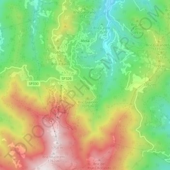
Name: Viola topographic map, elevation, terrain.
Location: Viola, Cuneo, Piedmont, Italy (44.24482 7.93995 44.30514 8.00356)
Average elevation: 1,051 m
Minimum elevation: 567 m
Maximum elevation: 1,750 m
Thank you for supporting this site ❤️
Make a donation
Make a donation
Other topographic maps
Click on a map to view its topography, its elevation and its terrain.
Thank you for supporting this site ❤️
Make a donation
Make a donation
Mont Vallonnet Nord / Cima las Blancias
Italy > Piedmont > Cuneo > Pietraporzio
Average elevation: 2,522 m