
Thank you for supporting this site ❤️
Make a donation
Make a donation
Pian di Rocca topographic map
Click on the map to display elevation.
Thank you for supporting this site ❤️
Make a donation
Make a donation
About this map
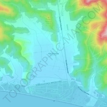
Name: Pian di Rocca topographic map, elevation, terrain.
Average elevation: 52 m
Minimum elevation: -3 m
Maximum elevation: 294 m
Thank you for supporting this site ❤️
Make a donation
Make a donation
Other topographic maps
Click on a map to view its topography, its elevation and its terrain.
Castello di Castiglione della Pescaia
Italia > Toscana > Grosseto > Castiglione della Pescaia
Average elevation: 20 m