
Make a donation
Kathikund topographic map
Click on the map to display elevation.
Make a donation
About this map
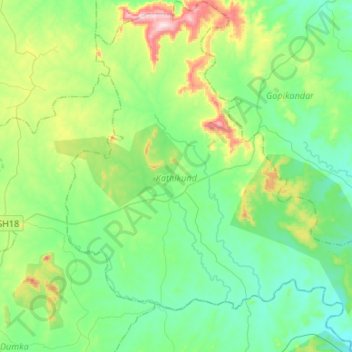
Name: Kathikund topographic map, elevation, terrain.
Location: Kathikund, Dumka, Jharkhand, 814103, India (24.24951 87.33908 24.49215 87.58418)
Average elevation: 173 m
Minimum elevation: 68 m
Maximum elevation: 497 m
Make a donation
Other topographic maps
Click on a map to view its topography, its elevation and its terrain.
Dhanbad
Dhanbad has an average elevation of 227 m (745 ft). Its geographical length (extending from north to south) is 15 miles (24 km) and the breadth (stretching across east to West) is 10 miles (16 km). It shares its boundaries with West Bengal in the eastern and southern part, Giridih and Dumka in the North and…
Average elevation: 212 m
Make a donation
Medininagar
India > Jharkhand > Medininagar(Daltonganj)
Medininagar is located at 24°02′N 84°04′E / 24.03°N 84.07°E / 24.03; 84.07. It has an average elevation of 215 m (705 ft).
Average elevation: 226 m
Make a donation
Make a donation