
Bokeloh topographic map
Interactive map
Click on the map to display elevation.
About this map
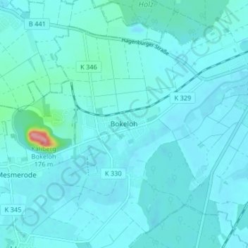
Name: Bokeloh topographic map, elevation, terrain.
Average elevation: 51 m
Minimum elevation: 41 m
Maximum elevation: 162 m
Die weiß-graue Abraumhalde ist ein so genannter Kalimandscharo; eine Höhe von 140 Metern wurde genehmigt.
Other topographic maps
Click on a map to view its topography, its elevation and its terrain.
Steinhuder Meer
Deutschland > Niedersachsen > Region Hannover > Wunstorf
Steinhuder Meer, Wunstorf, Region Hannover, Niedersachsen, Deutschland
Average elevation: 40 m
Idensen
Deutschland > Niedersachsen > Region Hannover > Wunstorf
Idensen, Wunstorf, Region Hannover, Niedersachsen, 31559, Deutschland
Average elevation: 51 m
Steinhude
Deutschland > Niedersachsen > Region Hannover > Wunstorf
Steinhude, Wunstorf, Region Hannover, Niedersachsen, Deutschland
Average elevation: 43 m
Luthe
Deutschland > Niedersachsen > Region Hannover > Wunstorf
Luthe, Wunstorf, Region Hannover, Niedersachsen, Deutschland
Average elevation: 46 m
Luthe
Deutschland > Niedersachsen > Region Hannover > Wunstorf
Luthe, Wunstorf, Region Hannover, Niedersachsen, Deutschland
Average elevation: 45 m