
Thank you for supporting this site ❤️
Make a donation
Make a donation
Uinta Mountains topographic map
Click on the map to display elevation.
Thank you for supporting this site ❤️
Make a donation
Make a donation
About this map
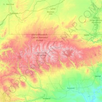
Name: Uinta Mountains topographic map, elevation, terrain.
Location: Uinta Mountains, Duchesne County, Utah, USA (40.47516 -111.19949 41.08660 -109.45679)
Average elevation: 2,363 m
Minimum elevation: 1,420 m
Maximum elevation: 4,098 m
Thank you for supporting this site ❤️
Make a donation
Make a donation
Other topographic maps
Click on a map to view its topography, its elevation and its terrain.