
Thank you for supporting this site ❤️
Make a donation
Make a donation
Adair Village topographic map
Click on the map to display elevation.
Thank you for supporting this site ❤️
Make a donation
Make a donation
About this map
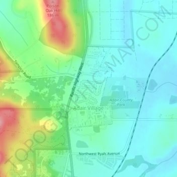
Name: Adair Village topographic map, elevation, terrain.
Location: Adair Village, Benton County, Oregon, United States (44.66879 -123.22285 44.68164 -123.21321)
Average elevation: 100 m
Minimum elevation: 67 m
Maximum elevation: 189 m
Thank you for supporting this site ❤️
Make a donation
Make a donation
Other topographic maps
Click on a map to view its topography, its elevation and its terrain.