
Make a donation
Tavannes topographic map
Click on the map to display elevation.
Make a donation
About this map
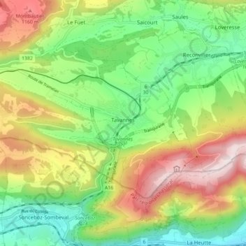
Name: Tavannes topographic map, elevation, terrain.
Average elevation: 879 m
Minimum elevation: 598 m
Maximum elevation: 1,294 m
Make a donation
Other topographic maps
Click on a map to view its topography, its elevation and its terrain.
Les Vacheries dessus
Suisse > Berne > Arrondissement administratif du Jura bernois > Le Fuet
Average elevation: 919 m
Chasseral
Suisse > Berne > Arrondissement administratif du Jura bernois > Nods
Average elevation: 1,399 m
Béroie
Suisse > Berne > Arrondissement administratif du Jura bernois > Saicourt
Average elevation: 998 m
Chasseral
Suisse > Berne > Arrondissement administratif du Jura bernois > Nods
Average elevation: 1,399 m
Make a donation
Les Cerniers
Suisse > Berne > Arrondissement administratif du Jura bernois > Rebévelier
Average elevation: 927 m
Les Gérinnes
Suisse > Berne > Arrondissement administratif du Jura bernois > Les Reussilles
Average elevation: 1,018 m
Envers des Convers
Suisse > Berne > Arrondissement administratif du Jura bernois > Renan (BE)
Average elevation: 1,076 m
Chaindon
Suisse > Berne > Arrondissement administratif du Jura bernois > Reconvilier
Average elevation: 845 m
Make a donation
Le Plan
Suisse > Berne > Arrondissement administratif du Jura bernois > Renan (BE)
Average elevation: 1,043 m
Les Reussilles
Suisse > Berne > Arrondissement administratif du Jura bernois
Average elevation: 1,022 m
Parc de l'Arc Jurassien
Suisse > Berne > Arrondissement administratif du Jura bernois > Moutier
Average elevation: 653 m
Les Prés-d'Orvin
Suisse > Berne > Arrondissement administratif du Jura bernois > Orvin
Average elevation: 1,092 m
Make a donation
Sous le Mont
Suisse > Berne > Arrondissement administratif du Jura bernois > Tavannes
Average elevation: 904 m
Les Savagnières-Dessous
Suisse > Berne > Arrondissement administratif du Jura bernois > Saint-Imier
Average elevation: 1,137 m
Sous la Sagne
Suisse > Berne > Arrondissement administratif du Jura bernois > Les Reussilles > Sous la Sagne
Average elevation: 1,013 m
Make a donation
Les Pontins
Suisse > Berne > Arrondissement administratif du Jura bernois > Saint-Imier
Average elevation: 1,062 m