
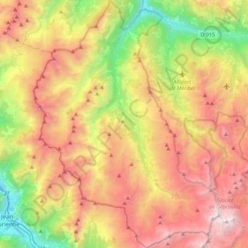
Les Belleville topographic map
Interactive map
Click on the map to display elevation.
About this map
Name: Les Belleville topographic map, elevation, terrain.
Average elevation: 1,919 m
Minimum elevation: 499 m
Maximum elevation: 3,533 m
Other topographic maps
Click on a map to view its topography, its elevation and its terrain.
Saint-Martin-de-Belleville
França > Auvergne-Rhône-Alpes > Savoie
Saint-Martin-de-Belleville, Les Belleville, Albertville, Savoie, Auvergne-Rhône-Alpes, França metropolitana, 73440, França
Average elevation: 2,004 m
Tignes
França > Auvergne-Rhône-Alpes > Savoie
Tignes, Albertville, Savoie, Auvergne-Rhône-Alpes, França metropolitana, 73320, França
Average elevation: 2,520 m
Belle Tour
França > Auvergne-Rhône-Alpes > Savoie > Flumet > Belle Tour
Belle Tour, Flumet, Albertville, Savoie, Auvergne-Rhône-Alpes, França metropolitana, 73590, França
Average elevation: 1,166 m