
Atta topographic map
Click on the map to display elevation.
About this map
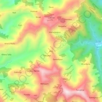
Name: Atta topographic map, elevation, terrain.
Average elevation: 1,004 m
Minimum elevation: 670 m
Maximum elevation: 1,316 m
Other topographic maps
Click on a map to view its topography, its elevation and its terrain.
Elephant Pound Rajaji National park Uttrakhand
India > Uttarakhand > Yamkeshwar
Average elevation: 455 m
Elephant Pound Rajaji National park Uttrakhand
India > Uttarakhand > Yamkeshwar
Average elevation: 455 m
Elephant Pound Rajaji National park Uttrakhand
India > Uttarakhand > Yamkeshwar
Average elevation: 455 m
Elephant Pound Rajaji National park Uttrakhand
India > Uttarakhand > Yamkeshwar
Average elevation: 455 m
Elephant Pound Rajaji National park Uttrakhand
India > Uttarakhand > Yamkeshwar
Average elevation: 455 m