
Vosbles topographic map
Interactive map
Click on the map to display elevation.
About this map
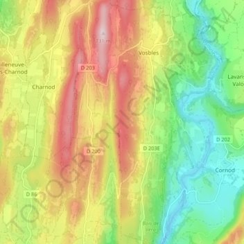
Name: Vosbles topographic map, elevation, terrain.
Average elevation: 489 m
Minimum elevation: 307 m
Maximum elevation: 716 m
L'altitude s'élève jusqu'à 731 m au nord-ouest du village, en forêt, entre les lieux-dits bois en Coquaine et bois de la Serra.
Other topographic maps
Click on a map to view its topography, its elevation and its terrain.
Chavagna
France > Bourgogne-Franche-Comté > Jura > Vosbles-Valfin > Chavagna
Chavagna, Vosbles, Vosbles-Valfin, Lons-le-Saunier, Jura, Bourgogne-Franche-Comté, France métropolitaine, 39240, France
Average elevation: 471 m