
Make a donation
Martinique topographic map
Click on the map to display elevation.
Make a donation
About this map
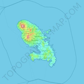
Name: Martinique topographic map, elevation, terrain.
Location: Martinique, France (14.22174 -61.43550 15.07951 -60.60228)
Average elevation: 22 m
Minimum elevation: 0 m
Maximum elevation: 1,339 m
Make a donation
Other topographic maps
Click on a map to view its topography, its elevation and its terrain.
Le Clos des Chênes
France > Centre-Val de Loire > Indre-et-Loire > Chouzé-sur-Loire
Average elevation: 30 m
Make a donation
Les Granges
France > Auvergne-Rhône-Alpes > Upper Savoy > Chamonix-Mont-Blanc > Les Bossons
Average elevation: 1,363 m
Make a donation
Make a donation
Make a donation
Make a donation
Make a donation
Make a donation
Mont Blanc / Monte Bianco
France > Auvergne-Rhône-Alpes > Upper Savoy > Saint-Gervais-les-Bains
The climate is cold and temperate (Köppen climate classification Cfb), and is greatly influenced by altitude. Being the highest part of the Alps, Mont Blanc and surrounding mountains can create their own weather patterns. Temperatures drop as the mountains gain in height, and the summit of Mont Blanc is a…
Average elevation: 4,092 m
Make a donation
Val Thorens
France > Auvergne-Rhône-Alpes > Savoy
Val Thorens ([val tɔʁɑ̃]) is a ski town in the Tarentaise Valley in the French Alps at an altitude of 2,300 m (7,500 ft). It is located in the commune of Saint-Martin-de-Belleville in the Savoie department. The resort forms part of the Les Trois Vallées ski area which, with over 600 km of slopes, is one…
Average elevation: 2,516 m
Make a donation
Make a donation
Make a donation
Make a donation
Orcières-Merlette
France > Provence-Alpes-Côte d'Azur > Hautes-Alpes > Orcières
Average elevation: 1,874 m
La Chervinière
France > Pays de la Loire > Vendée > Rives-du-Fougerais > Saint-Sulpice-en-Pareds
Average elevation: 87 m
Bionnay
France > Auvergne-Rhône-Alpes > Upper Savoy > Saint-Gervais-les-Bains
Average elevation: 1,276 m
Make a donation
Château-Observatoire Abbadia
France > Nouvelle-Aquitaine > Pyrénées-Atlantiques > Hendaye > Sopite
Average elevation: 25 m
Montrigon
France > Auvergne-Rhône-Alpes > Savoy > Bourg-Saint-Maurice > Arc 1600
Average elevation: 1,096 m
Make a donation
Make a donation
Mont Blanc / Monte Bianco
France > Auvergne-Rhône-Alpes > Upper Savoy > Saint-Gervais-les-Bains
The climate is cold and temperate (Köppen climate classification Cfb), and is greatly influenced by altitude. Being the highest part of the Alps, Mont Blanc and surrounding mountains can create their own weather patterns. Temperatures drop as the mountains gain in height, and the summit of Mont Blanc is a…
Average elevation: 4,092 m
Make a donation
Terres du Gd Sous Les Vign
France > Centre-Val de Loire > Loiret > Dordives > Le Grand-sous-les-Vignes
Average elevation: 93 m
Make a donation
Falkenstein Castle
France > Grand Est > Moselle > Philippsbourg
In 1981, the Vosges Club (club vosgien) in Strasbourg placed a marker at the castle summit showing the altitude and directions to nearby land features.
Average elevation: 269 m
Make a donation
Make a donation
Make a donation
Make a donation
Make a donation
Château Cos d'Estournel
France > Nouvelle-Aquitaine > Gironde > Saint-Estèphe > Cos
Average elevation: 14 m
Barre des Écrins
France > Provence-Alpes-Côte d'Azur > Hautes-Alpes > Vallouise-Pelvoux
The Barre des Écrins (French pronunciation: [baʁ dez‿ekʁɛ̃]) is a mountain in the French Alps with a peak elevation of 4,102 metres (13,458 ft). It is the highest peak of the Massif des Écrins and the Dauphiné Alps and the most southerly alpine peak in Europe that is higher than 4,000 metres. It is…
Average elevation: 3,222 m
Make a donation
Le Plan de l'Envers
France > Auvergne-Rhône-Alpes > Upper Savoy > Vallorcine
Average elevation: 1,721 m
Make a donation