
Fordingbridge topographic map
Interactive map
Click on the map to display elevation.
About this map
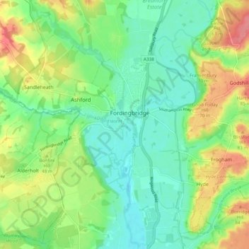
Name: Fordingbridge topographic map, elevation, terrain.
Average elevation: 46 m
Minimum elevation: 18 m
Maximum elevation: 94 m
Other topographic maps
Click on a map to view its topography, its elevation and its terrain.
Martin
United Kingdom > England > New Forest
Martin, New Forest, Hampshire, South East, England, United Kingdom
Average elevation: 103 m
Totton and Eling
United Kingdom > England > New Forest
Totton and Eling, New Forest, Hampshire, South East, England, United Kingdom
Average elevation: 13 m
Lymington and Pennington
United Kingdom > England > New Forest
Lymington and Pennington, New Forest, Hampshire, South East, England, United Kingdom
Average elevation: 9 m
Copythorne
United Kingdom > England > New Forest
Copythorne, New Forest, Hampshire, South East, England, United Kingdom
Average elevation: 36 m