
Gemeinde Sölden topographic map
Interactive map
Click on the map to display elevation.
About this map
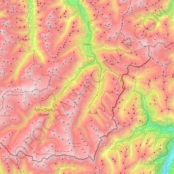
Name: Gemeinde Sölden topographic map, elevation, terrain.
Location: Gemeinde Sölden, Bezirk Imst, Tyrol, Autriche (46.76285 10.72601 47.02239 11.16810)
Average elevation: 2,483 m
Minimum elevation: 499 m
Maximum elevation: 3,721 m
Other topographic maps
Click on a map to view its topography, its elevation and its terrain.
Ötztal
Autriche > Tyrol > Bezirk Imst
Ötztal, Bezirk Imst, Tyrol, 6450, Autriche
Average elevation: 2,194 m
Gemeinde Jerzens
Autriche > Tyrol > Bezirk Imst
Gemeinde Jerzens, Bezirk Imst, Tyrol, 6474, Autriche
Average elevation: 1,954 m
Stadt Imst
Autriche > Tyrol > Bezirk Imst > Stadt Imst
Stadt Imst, Bezirk Imst, Tyrol, 6460, Autriche
Average elevation: 1,613 m