
Thank you for supporting this site ❤️
Make a donation
Make a donation
Reppentin topographic map
Click on the map to display elevation.
Thank you for supporting this site ❤️
Make a donation
Make a donation
About this map
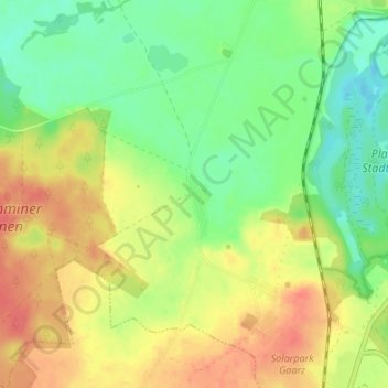
Name: Reppentin topographic map, elevation, terrain.
Average elevation: 83 m
Minimum elevation: 58 m
Maximum elevation: 110 m
Thank you for supporting this site ❤️
Make a donation
Make a donation
Other topographic maps
Click on a map to view its topography, its elevation and its terrain.
Plauer See
Deutschland > Mecklenburg-Vorpommern > Ludwigslust-Parchim > Plau am See
Average elevation: 79 m