
Make a donation
Nocupétaro topographic map
Click on the map to display elevation.
Make a donation
Nocupétaro
The municipality of Nocupétaro is located in the Tierra Caliente region of Michoacán at an elevation between 500 and 1,800 metres (1,600–5,900 ft). It borders the municipalities of Madero to the north, Carácuaro to the east, Turicato to the southwest, and Tacámbaro to the northwest. The municipality covers an area of 547.184 square kilometres (211.269 sq mi) and comprises 0.93% of the state's area.
Make a donation
About this map
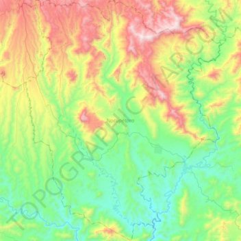
Name: Nocupétaro topographic map, elevation, terrain.
Location: Nocupétaro, Michoacán, Mexico (18.93149 -101.33195 19.22422 -101.08017)
Average elevation: 934 m
Minimum elevation: 479 m
Maximum elevation: 1,853 m
Make a donation
Other topographic maps
Click on a map to view its topography, its elevation and its terrain.
Make a donation
Ihuatzio
Mexico > Michoacán > Tzintzuntzan
Ihuatzio is located on the southeast of the Lake Pátzcuaro, about 8 kilometers southwest of the town center of Tzintzuntzan. Its average elevation is 2,052 meters above the sea level.
Average elevation: 2,052 m
Make a donation