
Grattavache topographic map
Interactive map
Click on the map to display elevation.
About this map
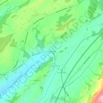
Name: Grattavache topographic map, elevation, terrain.
Average elevation: 868 m
Minimum elevation: 768 m
Maximum elevation: 1,121 m
Other topographic maps
Click on a map to view its topography, its elevation and its terrain.
Progens
Suisse > Fribourg > District de la Veveyse > La Verrerie
Progens, La Verrerie, District de la Veveyse, Fribourg, 1624, Suisse
Average elevation: 854 m