
Thank you for supporting this site ❤️
Make a donation
Make a donation
Siljan topographic map
Click on the map to display elevation.
Thank you for supporting this site ❤️
Make a donation
Make a donation
About this map
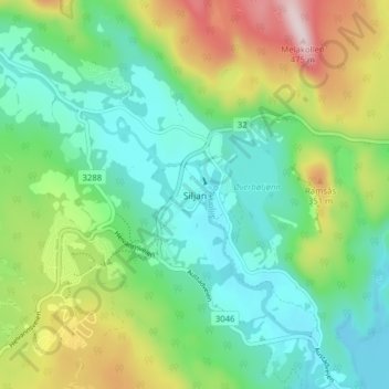
Name: Siljan topographic map, elevation, terrain.
Location: Siljan, Vestfold og Telemark, 3748, Norge (59.25908 9.70942 59.29908 9.74942)
Average elevation: 193 m
Minimum elevation: 72 m
Maximum elevation: 460 m
Thank you for supporting this site ❤️
Make a donation
Make a donation
Other topographic maps
Click on a map to view its topography, its elevation and its terrain.
Thank you for supporting this site ❤️
Make a donation
Make a donation
Thank you for supporting this site ❤️
Make a donation
Make a donation
Thank you for supporting this site ❤️
Make a donation
Make a donation
Thank you for supporting this site ❤️
Make a donation
Make a donation