
Sumy Oblast topographic map
Interactive map
Click on the map to display elevation.
About this map
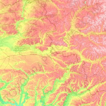
Name: Sumy Oblast topographic map, elevation, terrain.
Location: Sumy Oblast, Ukraine (50.11024 32.94372 52.36671 35.69266)
Average elevation: 170 m
Minimum elevation: 90 m
Maximum elevation: 271 m
The Sumy Oblast is situated in the northeastern part of Ukraine. It is situated on a border of two historical regions of Ukraine — Cossack Hetmanate (annexed by Russia in the 18th century as Little Russia, previously known as Severia) and Sloboda Ukraine. Elevation is 110–240m above sea level. The area of the oblast (23,800 km2), comprises about 3.95% of the total area of the country.
Other topographic maps
Click on a map to view its topography, its elevation and its terrain.