
San Vicente topographic map
Interactive map
Click on the map to display elevation.
About this map
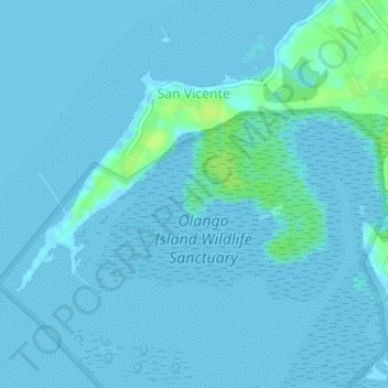
Name: San Vicente topographic map, elevation, terrain.
Location: San Vicente, Lapu-Lapu, Central Visayas, Philippines (10.23632 124.01048 10.26244 124.04261)
Average elevation: 2 m
Minimum elevation: -3 m
Maximum elevation: 13 m
Other topographic maps
Click on a map to view its topography, its elevation and its terrain.
Gun-ob
Gun-ob, Lapu-Lapu, Central Visayas, 6016, Philippines
Average elevation: 3 m
Tungasan
Tungasan, Lapu-Lapu, Central Visayas, Philippines
Average elevation: 3 m
Sangi
Philippines > Lapu-Lapu > Pajo
Sangi, Pajo, Lapu-Lapu, Central Visayas, 3359, Philippines
Average elevation: 6 m
Basak
Basak, Lapu-Lapu, Central Visayas, 6016, Philippines
Average elevation: 5 m
Olango Island
Philippines > Lapu-Lapu > Sabang
Olango Island, Sabang, Lapu-Lapu, Central Visayas, Philippines
Average elevation: 2 m
Pajac
Pajac, Lapu-Lapu, Central Visayas, 6015, Philippines
Average elevation: 6 m