
Thank you for supporting this site ❤️
Make a donation
Make a donation
Mara Arbarei/Villamar topographic map
Click on the map to display elevation.
Thank you for supporting this site ❤️
Make a donation
Make a donation
About this map
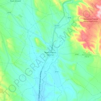
Name: Mara Arbarei/Villamar topographic map, elevation, terrain.
Location: Mara Arbarei/Villamar, Sud Sardegna, Sardinia, 09020, Italy (39.58355 8.92004 39.65762 9.02613)
Average elevation: 152 m
Minimum elevation: 93 m
Maximum elevation: 335 m
Thank you for supporting this site ❤️
Make a donation
Make a donation
Other topographic maps
Click on a map to view its topography, its elevation and its terrain.
Thank you for supporting this site ❤️
Make a donation
Make a donation
Thank you for supporting this site ❤️
Make a donation
Make a donation
Thank you for supporting this site ❤️
Make a donation
Make a donation
Monte Maria
Italy > Sardinia > Cagliari > Quartu Sant'Aleni/Quartu Sant'Elena
Average elevation: 504 m
Spiaggia della Balena
Italy > Sardinia > Aristanis/Oristano > Cùllieri/Cuglieri > Torre del Pozzo
Average elevation: 31 m
Thank you for supporting this site ❤️
Make a donation
Make a donation
Thank you for supporting this site ❤️
Make a donation
Make a donation