
Jackson County topographic map
Click on the map to display elevation.
Jackson County
Most of Jackson County is a high relatively broad intermontane basin known as North Park, which covers 1,613 square miles (4,180 km2). This basin opens north into Wyoming and is rimmed on the west by the Park Range and Sierra Madre Range, on the south by the Rabbit Ears Range and the Never Summer Mountains, and on the east by the Medicine Bow Mountains. Elevations range from 7,800 to 12,953 feet (3,948 m) above sea level and is home to the head waters of the North Platte River. The term park is derived from parc, the French word for game preserve. At one time North Park was filled with herds of deer, antelope and buffalo. There were so many buffalo in the area the Ute Tribe gave North Park the name "Bull Pen." Now deer, elk, and cattle vie for the same area.
About this map
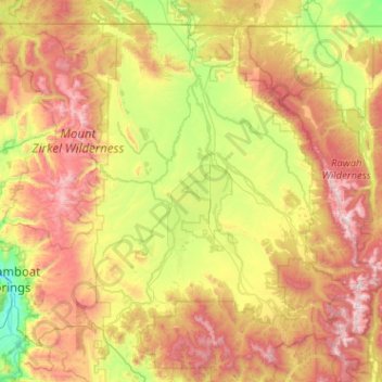
Name: Jackson County topographic map, elevation, terrain.
Location: Jackson County, Colorado, United States (40.32338 -106.87322 41.00266 -105.85176)
Average elevation: 2,751 m
Minimum elevation: 2,047 m
Maximum elevation: 3,899 m
Other topographic maps
Click on a map to view its topography, its elevation and its terrain.
Vail
United States > Colorado > Eagle County
Vail's average elevation is 8,150 feet (2,480 m) above sea level. The town has a total area of 4.5 square miles (12 km2), with no lakes (there is, however, at least one pond). Gore Creek flows from east to west through the center of town.
Average elevation: 2,953 m