
Thank you for supporting this site ❤️
Make a donation
Make a donation
Berkeley County topographic map
Click on the map to display elevation.
Thank you for supporting this site ❤️
Make a donation
Make a donation
About this map
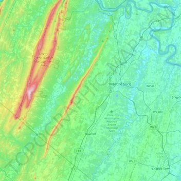
Name: Berkeley County topographic map, elevation, terrain.
Location: Berkeley County, West Virginia, United States (39.26448 -78.22991 39.62127 -77.82342)
Average elevation: 203 m
Minimum elevation: 95 m
Maximum elevation: 655 m
Thank you for supporting this site ❤️
Make a donation
Make a donation
Other topographic maps
Click on a map to view its topography, its elevation and its terrain.