
Monte Rotondo topographic map
Interactive map
Click on the map to display elevation.
About this map
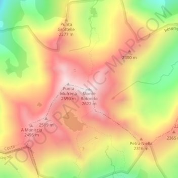
Name: Monte Rotondo topographic map, elevation, terrain.
Average elevation: 2,206 m
Minimum elevation: 1,707 m
Maximum elevation: 2,579 m
Monte Rotondo (korsisch: Monte Ritondu) ist ein 2622 m hoher Granitgipfel mitten auf der Insel Korsika. Mit dieser Höhe ist er nach dem Monte Cinto der zweithöchste Berg auf Korsika.