
Thank you for supporting this site ❤️
Make a donation
Make a donation
Lempster topographic map
Click on the map to display elevation.
Thank you for supporting this site ❤️
Make a donation
Make a donation
About this map
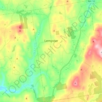
Name: Lempster topographic map, elevation, terrain.
Average elevation: 425 m
Minimum elevation: 252 m
Maximum elevation: 710 m
Thank you for supporting this site ❤️
Make a donation
Make a donation
Other topographic maps
Click on a map to view its topography, its elevation and its terrain.
Kolelemook Lake
United States > New Hampshire > Sullivan County > Springfield
Average elevation: 463 m
North Charlestown
United States > New Hampshire > Sullivan County > Charlestown
Average elevation: 162 m
South Charlestown
United States > New Hampshire > Sullivan County > Charlestown
Average elevation: 153 m
Thank you for supporting this site ❤️
Make a donation
Make a donation
Thank you for supporting this site ❤️
Make a donation
Make a donation