
Thank you for supporting this site ❤️
Make a donation
Make a donation
Obolonskyi district topographic map
Click on the map to display elevation.
Thank you for supporting this site ❤️
Make a donation
Make a donation
About this map
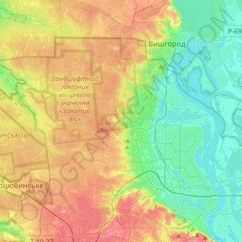
Name: Obolonskyi district topographic map, elevation, terrain.
Location: Obolonskyi district, Kyiv, Ukraine (50.47715 30.29749 50.58649 30.54451)
Average elevation: 136 m
Minimum elevation: 87 m
Maximum elevation: 212 m
Thank you for supporting this site ❤️
Make a donation
Make a donation
Other topographic maps
Click on a map to view its topography, its elevation and its terrain.