
Thank you for supporting this site ❤️
Make a donation
Make a donation
Urdaneta topographic map
Click on the map to display elevation.
Thank you for supporting this site ❤️
Make a donation
Make a donation
About this map
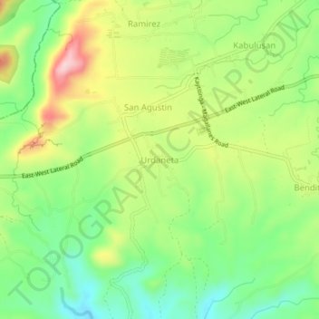
Name: Urdaneta topographic map, elevation, terrain.
Location: Urdaneta, Magallanes, Cavite, Calabarzon, 4113, Philippines (14.14481 120.71226 14.18481 120.75226)
Average elevation: 177 m
Minimum elevation: 86 m
Maximum elevation: 305 m
Thank you for supporting this site ❤️
Make a donation
Make a donation
Other topographic maps
Click on a map to view its topography, its elevation and its terrain.