
Thank you for supporting this site ❤️
Make a donation
Make a donation
Umpucan topographic map
Click on the map to display elevation.
Thank you for supporting this site ❤️
Make a donation
Make a donation
About this map
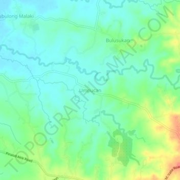
Name: Umpucan topographic map, elevation, terrain.
Location: Umpucan, San Ildefonso, Bulacan, Central Luzon, Philippines (15.05096 120.99115 15.09096 121.03115)
Average elevation: 40 m
Minimum elevation: 21 m
Maximum elevation: 84 m
Thank you for supporting this site ❤️
Make a donation
Make a donation
Other topographic maps
Click on a map to view its topography, its elevation and its terrain.