Geolocate

Still topographic map

Click on the map to display elevation.

About this map

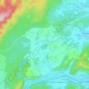
Name: Still topographic map, elevation, terrain.

Location: Still, Molsheim, Bas-Rhin, Grand Est, Metropolitan France, 67190, France (48.54295 7.31129 48.59048 7.43079)

Average elevation: 283 m

Minimum elevation: 180 m

Maximum elevation: 672 m

Other topographic maps

Click on a map to view its topography, its elevation and its terrain.

Le Haut des Monts

France > Grand Est > Bas-Rhin > Belmont

Average elevation: 849 m

Strasbourg

France > Grand Est > Bas-Rhin > Strasbourg

Average elevation: 154 m

Taubensee

France > Grand Est > Bas-Rhin > Niederbronn-les-Bains

Average elevation: 396 m

Ath

France > Grand Est > Bas-Rhin > Diemeringen

Average elevation: 255 m

Altenhof

France > Grand Est > Bas-Rhin > Strasbourg

Average elevation: 138 m

Altenberg

France > Grand Est > Bas-Rhin > Wolxheim

Average elevation: 211 m

Altenstadt

France > Grand Est > Bas-Rhin > Wissembourg

Average elevation: 172 m

Le Climont

France > Grand Est > Bas-Rhin > Urbeis

Average elevation: 621 m