
Río Turia topographic map
Interactive map
Click on the map to display elevation.
About this map
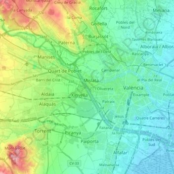
Name: Río Turia topographic map, elevation, terrain.
Average elevation: 37 m
Minimum elevation: -6 m
Maximum elevation: 141 m
Other topographic maps
Click on a map to view its topography, its elevation and its terrain.
Xirivella
España > Comunidad Valenciana > Xirivella
Xirivella, Huerta Oeste, Valencia, Comunidad Valenciana, 46950, España
Average elevation: 31 m