
Centre Ville topographic map
Interactive map
Click on the map to display elevation.
About this map
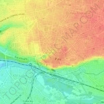
Name: Centre Ville topographic map, elevation, terrain.
Average elevation: 199 m
Minimum elevation: 168 m
Maximum elevation: 223 m
Other topographic maps
Click on a map to view its topography, its elevation and its terrain.
Pau
Frankreich > Neu-Aquitanien > Pau
Pau, Pyrenäen-Atlantik, Neu-Aquitanien, Metropolitanes Frankreich, 64000, Frankreich
Average elevation: 205 m