
Thank you for supporting this site ❤️
Make a donation
Make a donation
National Mall topographic map
Click on the map to display elevation.
Thank you for supporting this site ❤️
Make a donation
Make a donation
About this map
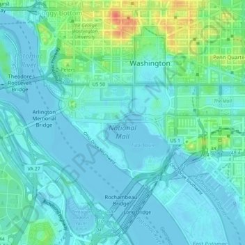
Name: National Mall topographic map, elevation, terrain.
Average elevation: 11 m
Minimum elevation: -3 m
Maximum elevation: 53 m
Thank you for supporting this site ❤️
Make a donation
Make a donation
Other topographic maps
Click on a map to view its topography, its elevation and its terrain.
United States National Arboretum
United States > District of Columbia > Washington
Average elevation: 21 m
Thank you for supporting this site ❤️
Make a donation
Make a donation
United States National Arboretum
United States > District of Columbia > Washington
Average elevation: 21 m
Thank you for supporting this site ❤️
Make a donation
Make a donation