
Mrągowo County topographic map
Interactive map
Click on the map to display elevation.
About this map
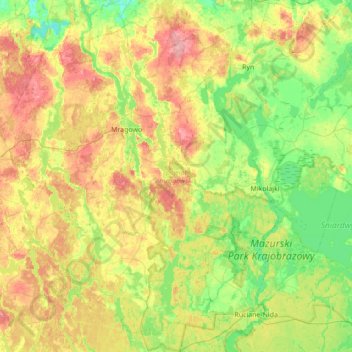
Name: Mrągowo County topographic map, elevation, terrain.
Location: Mrągowo County, Warmian-Masurian Voivodeship, Poland (53.62551 21.05137 53.99622 21.74382)
Average elevation: 141 m
Minimum elevation: 98 m
Maximum elevation: 214 m
Other topographic maps
Click on a map to view its topography, its elevation and its terrain.
gmina Świątki
Poland > Warmian-Masurian Voivodeship > Olsztyn County
gmina Świątki, Olsztyn County, Warmian-Masurian Voivodeship, Poland
Average elevation: 120 m
Działdowo
Poland > Warmian-Masurian Voivodeship > Działdowo County
Działdowo, Działdowo County, Warmian-Masurian Voivodeship, 13-201, Poland
Average elevation: 161 m
Działdowo County
Poland > Warmian-Masurian Voivodeship
Działdowo County, Warmian-Masurian Voivodeship, Poland
Average elevation: 159 m
Elk
Poland > Warmian-Masurian Voivodeship > Elk
Elk, powiat ełcki, Warmian-Masurian Voivodeship, Poland
Average elevation: 129 m
Morąg
Poland > Warmian-Masurian Voivodeship > Morąg
Morąg, gmina Morąg, powiat ostródzki, Warmian-Masurian Voivodeship, 14-300, Poland
Average elevation: 116 m
Działdowo
Poland > Warmian-Masurian Voivodeship > Działdowo
Działdowo, powiat działdowski, Warmian-Masurian Voivodeship, 13-201, Poland
Average elevation: 161 m