
Thank you for supporting this site ❤️
Make a donation
Make a donation
L'Aquila topographic map
Click on the map to display elevation.
Thank you for supporting this site ❤️
Make a donation
Make a donation
L'Aquila
Close to the highest of the Apennine summits, L'Aquila is positioned at an elevation of 721 metres (2,365 ft) in the Valley of the Aterno-Pescara, situated between four mountain peaks above 2,000 metres (6,600 ft).
Thank you for supporting this site ❤️
Make a donation
Make a donation
About this map
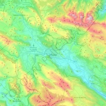
Name: L'Aquila topographic map, elevation, terrain.
Location: L'Aquila, Abruzzo, Italy (42.17658 13.17723 42.53155 13.65410)
Average elevation: 1,192 m
Minimum elevation: 510 m
Maximum elevation: 2,844 m
Thank you for supporting this site ❤️
Make a donation
Make a donation
Other topographic maps
Click on a map to view its topography, its elevation and its terrain.