
Andernach topographic map
Interactive map
Click on the map to display elevation.
About this map
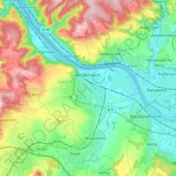
Name: Andernach topographic map, elevation, terrain.
Average elevation: 154 m
Minimum elevation: 52 m
Maximum elevation: 360 m
Other topographic maps
Click on a map to view its topography, its elevation and its terrain.
Burg Eltz
Allemagne > Rhénanie-Palatinat > Landkreis Mayen-Koblenz > Wierschem
Burg Eltz, Wierschem, Maifeld, Landkreis Mayen-Koblenz, Rhénanie-Palatinat, 56294, Allemagne
Average elevation: 219 m
Sankt Jost
Allemagne > Rhénanie-Palatinat > Landkreis Mayen-Koblenz > Langenfeld
Sankt Jost, Langenfeld, Vordereifel, Landkreis Mayen-Koblenz, Rhénanie-Palatinat, Allemagne
Average elevation: 476 m
Rieden
Allemagne > Rhénanie-Palatinat > Landkreis Mayen-Koblenz > Rieden
Rieden, Mendig, Landkreis Mayen-Koblenz, Rhénanie-Palatinat, 56745, Allemagne
Average elevation: 460 m