
Santander topographic map
Interactive map
Click on the map to display elevation.
About this map
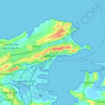
Name: Santander topographic map, elevation, terrain.
Location: Santander, Cantabria, España (43.43442 -3.88903 43.49488 -3.76325)
Average elevation: 10 m
Minimum elevation: -5 m
Maximum elevation: 97 m
Other topographic maps
Click on a map to view its topography, its elevation and its terrain.
Herrán
España > Cantabria > Santillana del Mar
Herrán, Santillana del Mar, Cantabria, 39360, España
Average elevation: 109 m