
Make a donation
Herne Bay topographic map
Click on the map to display elevation.
Make a donation
About this map
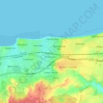
Name: Herne Bay topographic map, elevation, terrain.
Location: Herne Bay, Kent, England, United Kingdom (51.35366 1.08662 51.37642 1.17813)
Average elevation: 17 m
Minimum elevation: 0 m
Maximum elevation: 59 m
Make a donation
Other topographic maps
Click on a map to view its topography, its elevation and its terrain.
Barden Lake
United Kingdom > England > Kent > Tonbridge and Malling > Tonbridge
Average elevation: 33 m
Make a donation
Paul's Lake
United Kingdom > England > Kent > Dartford > Sutton at Hone > Lane End
Average elevation: 34 m
Make a donation
Make a donation
Make a donation
Make a donation
Make a donation
Make a donation
Make a donation
Make a donation
Make a donation
Make a donation
Make a donation
Ightham Common
United Kingdom > England > Kent > Tonbridge and Malling > Ightham
Average elevation: 145 m
Make a donation
Make a donation
Romney, Hythe and Dymchurch Railway
United Kingdom > England > Kent > Folkestone and Hythe > St. Mary in the Marsh
Average elevation: 1 m
Make a donation
Faversham Creek
United Kingdom > England > Kent > Borough of Swale > Faversham > Oare
Average elevation: 11 m
St Margaret's Bay
United Kingdom > England > Kent > Dover > St. Margaret's at Cliffe
Average elevation: 38 m
Make a donation
Make a donation
Make a donation
Make a donation
Hickmans Green
United Kingdom > England > Kent > Borough of Swale > Boughton Street
Average elevation: 63 m
Knatts Valley
United Kingdom > England > Kent > Sevenoaks > East Hill > Knockmill
Average elevation: 170 m
Make a donation
Make a donation
Make a donation
Make a donation
Chalybeate Spring
United Kingdom > England > Kent > Tunbridge Wells > Kilndown
Average elevation: 65 m
Make a donation
Rusthall Common Cricket Ground
United Kingdom > England > Kent > Tunbridge Wells > Rusthall
Average elevation: 99 m
Make a donation