
Thank you for supporting this site ❤️
Make a donation
Make a donation
Hoa Lư topographic map
Click on the map to display elevation.
Thank you for supporting this site ❤️
Make a donation
Make a donation
About this map
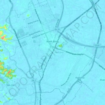
Name: Hoa Lư topographic map, elevation, terrain.
Location: Hoa Lư, Ninh Bình Province, Vietnam (20.17239 105.87746 20.32739 106.02408)
Average elevation: 8 m
Minimum elevation: -12 m
Maximum elevation: 186 m
Thank you for supporting this site ❤️
Make a donation
Make a donation
Other topographic maps
Click on a map to view its topography, its elevation and its terrain.
Thank you for supporting this site ❤️
Make a donation
Make a donation
Thank you for supporting this site ❤️
Make a donation
Make a donation