
Thank you for supporting this site ❤️
Make a donation
Make a donation
Bosques de Monterreal topographic map
Click on the map to display elevation.
Thank you for supporting this site ❤️
Make a donation
Make a donation
About this map
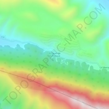
Name: Bosques de Monterreal topographic map, elevation, terrain.
Location: Bosques de Monterreal, Arteaga, Coahuila, México (25.21241 -100.45379 25.25241 -100.41379)
Average elevation: 2,896 m
Minimum elevation: 2,551 m
Maximum elevation: 3,467 m
Thank you for supporting this site ❤️
Make a donation
Make a donation
Other topographic maps
Click on a map to view its topography, its elevation and its terrain.
plaza de San Antonio de las Alazanas
México > Coahuila > Arteaga > San Antonio de Las Alazanas
Average elevation: 2,195 m