
Make a donation
Linares topographic map
Click on the map to display elevation.
Make a donation
Linares
Most of the territory of the municipality is located within the central plain or "depresión intermedia" (Valle Central de Chile). Some low altitude hills are located in the westernmost part of the municipality, while its easternmost part is marked by the presence of the foothills of the Andes mountains. The municipality of Linares is bordered on the west by San Javier; on the north by Villa Alegre, Yerbas Buenas and Colbún; on the east, by Colbún, and on the south, by Longaví. The municipality of Colbún occupies the easternmost strip of the province, where some of the highest provincial peaks are located, as are the sources of several of the main rivers.
Make a donation
About this map
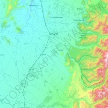
Name: Linares topographic map, elevation, terrain.
Location: Linares, Provincia de Linares, Maule Region, Chile (-36.22591 -71.79710 -35.70333 -71.00628)
Average elevation: 377 m
Minimum elevation: 74 m
Maximum elevation: 2,440 m
Make a donation
Other topographic maps
Click on a map to view its topography, its elevation and its terrain.
Los Cristales
Chile > Maule Region > Provincia de Linares > Longaví > Los Cristales
Average elevation: 160 m