
Graide topographic map
Interactive map
Click on the map to display elevation.
About this map
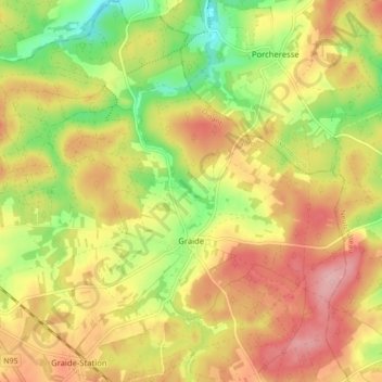
Name: Graide topographic map, elevation, terrain.
Location: Graide, Bièvre, Dinant, Province de Namur, Wallonie, Belgique (49.93071 5.02093 49.98675 5.10248)
Average elevation: 376 m
Minimum elevation: 301 m
Maximum elevation: 440 m
Other topographic maps
Click on a map to view its topography, its elevation and its terrain.
Naomé
Belgique > Province de Namur > Dinant > Bièvre
Naomé, Bièvre, Dinant, Province de Namur, Wallonie, Belgique
Average elevation: 396 m