
Thank you for supporting this site ❤️
Make a donation
Make a donation
Municipio El Hatillo topographic map
Click on the map to display elevation.
Thank you for supporting this site ❤️
Make a donation
Make a donation
About this map
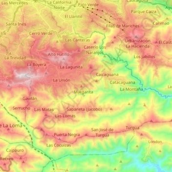
Name: Municipio El Hatillo topographic map, elevation, terrain.
Location: Municipio El Hatillo, Estado Miranda, 1083, Venezuela (10.35550 -66.85149 10.45918 -66.69487)
Average elevation: 907 m
Minimum elevation: 297 m
Maximum elevation: 1,495 m
Thank you for supporting this site ❤️
Make a donation
Make a donation
Other topographic maps
Click on a map to view its topography, its elevation and its terrain.
Sector Cantarrana
Venezuela > Estado Miranda > Municipio El Hatillo > Caracas
Average elevation: 1,165 m