
Make a donation
Sindagi topographic map
Click on the map to display elevation.
Make a donation
Sindagi
Sindagi is located at 16°55′N 76°14′E / 16.92°N 76.23°E / 16.92; 76.23. It has an average elevation of 500 metres (1640 feet). Sindagi is 60 km/37.28 miles away from the main district city of Bijapur, and 545 km/338.95 miles from the state capital, Bangalore. The nearest major railway station to Sindagi is at Indi (50 km), and the nearest airport is at Kalaburagi (96 km). Sindagi is a lesser Rainy Area and Most of the Area is Dry land. And Sindagi has a Good Planned City in Vijaypura District . Sindagi is Having Good Transportation System With National Highway 50.
Make a donation
About this map
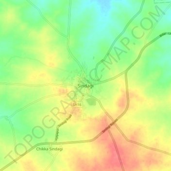
Name: Sindagi topographic map, elevation, terrain.
Location: Sindagi, Sindagi taluku, Vijayapura, Karnataka, 586128, India (16.87948 76.19503 16.95948 76.27503)
Average elevation: 504 m
Minimum elevation: 475 m
Maximum elevation: 537 m
Make a donation