Make a donation
Flat Rock topographic map
Click on the map to display elevation.
Make a donation
About this map
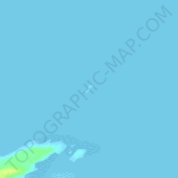
Name: Flat Rock topographic map, elevation, terrain.
Location: Flat Rock, Newfoundland, Newfoundland and Labrador, Canada (48.89699 -53.79898 48.89819 -53.79693)
Average elevation: 0 m
Minimum elevation: -1 m
Maximum elevation: 16 m
Make a donation
Other topographic maps
Click on a map to view its topography, its elevation and its terrain.
Make a donation
Avalon Peninsula
Canada > Newfoundland and Labrador > Spaniard's Bay > Tilton
Average elevation: 157 m
Make a donation
Make a donation
Make a donation
Clarenville
Canada > Newfoundland and Labrador
The Clarenville area has many of the physical features characteristic of the East Coast of Newfoundland and has a marine climate. It lies along the coastal slopes which rise from the Atlantic Ocean towards the interior central plateau of the island. The dominating physical feature is a ridge of broken peaks…
Average elevation: 102 m
Make a donation
Make a donation
Make a donation
Blue Hills of Couteau
Canada > Newfoundland and Labrador > unincorporated Newfoundland
Average elevation: 496 m
Make a donation
Make a donation
Make a donation
Make a donation
Make a donation
Make a donation
Make a donation
Make a donation
Outer Cove
Canada > Newfoundland and Labrador > Logy Bay-Middle Cove-Outer Cove
Average elevation: 47 m
Make a donation
Make a donation
Memorial University of Newfoundland main campus
Canada > Newfoundland and Labrador > St. John's
Average elevation: 78 m
Make a donation
Make a donation
Make a donation
Pistolet Bay Provincial Park
Canada > Newfoundland and Labrador > unincorporated Newfoundland
Average elevation: 21 m
Make a donation
Pistolet Bay Provincial Park
Canada > Newfoundland and Labrador > unincorporated Newfoundland
Average elevation: 21 m
Make a donation
Make a donation
Make a donation
Make a donation
