
Thank you for supporting this site ❤️
Make a donation
Make a donation
Swornegacie topographic map
Click on the map to display elevation.
Thank you for supporting this site ❤️
Make a donation
Make a donation
About this map
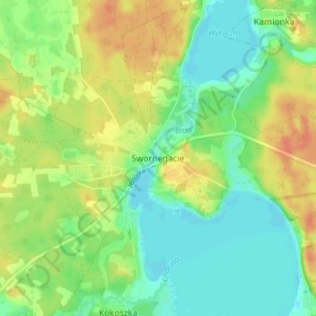
Name: Swornegacie topographic map, elevation, terrain.
Average elevation: 130 m
Minimum elevation: 114 m
Maximum elevation: 151 m
Thank you for supporting this site ❤️
Make a donation
Make a donation
Other topographic maps
Click on a map to view its topography, its elevation and its terrain.
Bory Tucholskie National Park
Poland > Pomeranian Voivodeship > Chojnice County > Józefowo
Average elevation: 135 m
Thank you for supporting this site ❤️
Make a donation
Make a donation