
Thank you for supporting this site ❤️
Make a donation
Make a donation
Pian della Chiesa topographic map
Click on the map to display elevation.
Thank you for supporting this site ❤️
Make a donation
Make a donation
About this map
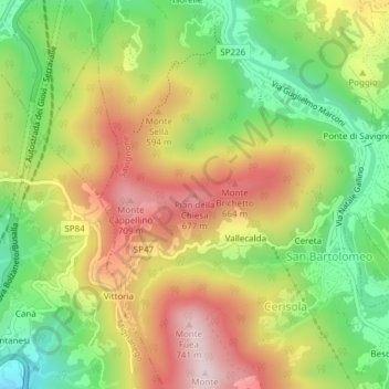
Name: Pian della Chiesa topographic map, elevation, terrain.
Location: Pian della Chiesa, Savignone, Genova, Liguria, 16012, Italia (44.55272 8.96240 44.55282 8.96250)
Average elevation: 495 m
Minimum elevation: 282 m
Maximum elevation: 729 m
Thank you for supporting this site ❤️
Make a donation
Make a donation