
Thank you for supporting this site ❤️
Make a donation
Make a donation
La Gouille topographic map
Click on the map to display elevation.
Thank you for supporting this site ❤️
Make a donation
Make a donation
About this map
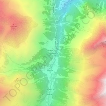
Name: La Gouille topographic map, elevation, terrain.
Location: La Gouille, Evolène, Hérens, Wallis, 1983, Switzerland (46.03361 7.46974 46.07361 7.50974)
Average elevation: 2,320 m
Minimum elevation: 1,510 m
Maximum elevation: 3,295 m
Thank you for supporting this site ❤️
Make a donation
Make a donation
Other topographic maps
Click on a map to view its topography, its elevation and its terrain.