
Thank you for supporting this site ❤️
Make a donation
Make a donation
Hurlford topographic map
Click on the map to display elevation.
Thank you for supporting this site ❤️
Make a donation
Make a donation
About this map
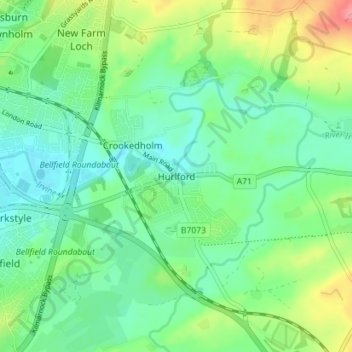
Name: Hurlford topographic map, elevation, terrain.
Location: Hurlford, East Ayrshire, Scotland, KA1 5BZ, United Kingdom (55.58134 -4.47391 55.62134 -4.43391)
Average elevation: 49 m
Minimum elevation: 22 m
Maximum elevation: 111 m
Thank you for supporting this site ❤️
Make a donation
Make a donation
Other topographic maps
Click on a map to view its topography, its elevation and its terrain.
Thank you for supporting this site ❤️
Make a donation
Make a donation
Thank you for supporting this site ❤️
Make a donation
Make a donation