
Thank you for supporting this site ❤️
Make a donation
Make a donation
Anjean topographic map
Click on the map to display elevation.
Thank you for supporting this site ❤️
Make a donation
Make a donation
About this map
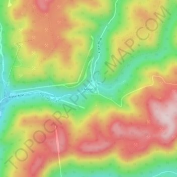
Name: Anjean topographic map, elevation, terrain.
Location: Anjean, Greenbrier County, West Virginia, United States (38.00012 -80.65314 38.04012 -80.61314)
Average elevation: 971 m
Minimum elevation: 776 m
Maximum elevation: 1,156 m
Thank you for supporting this site ❤️
Make a donation
Make a donation
Other topographic maps
Click on a map to view its topography, its elevation and its terrain.
Thank you for supporting this site ❤️
Make a donation
Make a donation
Alderson Recreation Area
United States > West Virginia > Greenbrier County > Alderson
Average elevation: 501 m
Thank you for supporting this site ❤️
Make a donation
Make a donation