
Wheelon topographic map
Click on the map to display elevation.
About this map
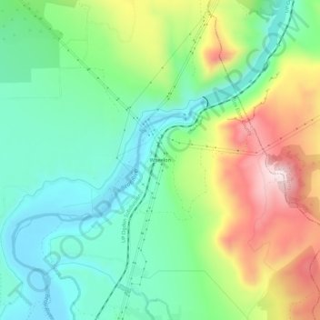
Name: Wheelon topographic map, elevation, terrain.
Location: Wheelon, Box Elder County, Utah, 84306, United States (41.80909 -112.07606 41.84909 -112.03606)
Average elevation: 1,455 m
Minimum elevation: 1,297 m
Maximum elevation: 1,750 m
Other topographic maps
Click on a map to view its topography, its elevation and its terrain.
Brigham City
United States > Utah > Box Elder County
According to the United States Census Bureau, the city has a total area of 24.2 square miles (62.6 km2), of which 23.8 square miles (61.7 km2) is land and 0.35 square miles (0.9 km2), or 1.40%, is water. It lies at an elevation of 4,315 feet (1,315 m).
Average elevation: 1,529 m
Hansel Mountains
United States > Utah > Box Elder County
Located in northeast Box Elder County, the southwest of the range abuts the Locomotive Springs State Wildlife Management Area; the northeast end of the range ends at a lower elevation divide between the North Hansel Mountains that lie on the Utah-Idaho border. Snowville lies on Deep Creek in the Sage Valley to…
Average elevation: 1,472 m
Brigham City
United States > Utah > Box Elder County
According to the United States Census Bureau, the city has a total area of 24.2 square miles (62.6 km2), of which 23.8 square miles (61.7 km2) is land and 0.35 square miles (0.9 km2), or 1.40%, is water. It lies at an elevation of 4,315 feet (1,315 m).
Average elevation: 1,529 m