
Thank you for supporting this site ❤️
Make a donation
Make a donation
Alouette Lake topographic map
Click on the map to display elevation.
Thank you for supporting this site ❤️
Make a donation
Make a donation
About this map
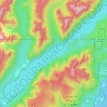
Name: Alouette Lake topographic map, elevation, terrain.
Average elevation: 549 m
Minimum elevation: 77 m
Maximum elevation: 1,481 m
Thank you for supporting this site ❤️
Make a donation
Make a donation
Other topographic maps
Click on a map to view its topography, its elevation and its terrain.
Cliff Falls
Canada > British Columbia > Metro Vancouver Regional District > Maple Ridge
Average elevation: 106 m
Golden Ears
Canada > British Columbia > Metro Vancouver Regional District > Maple Ridge
Average elevation: 189 m